WEATHER WARNINGS for CANARY ISLANDS
There are warnings of strong winds, scattered thunderstorms and moderate to heavy rainfall for La Gomera and all the western Canaries, later extending east. It will remain fairly warm however with around 25ºC. (See bottom of post for 9 # updates)
A very complex weather situation has produced a large area of low pressure far west of us. This low is slowly approaching and will be followed by another, while a further two low pressure systems are in the north preventing the usually rapid passage of the western lows. This could cause the precipitation associated with the western low to become almost stationary over the Canaries and bring some more prolonged spells of rain.
To add to this potential, the large low relatively far west of us is bringing in extra tropical energy from the outer southern flanks of the headline-making storm Sandy which is affecting the east coast of the US. The large low in turn may be partially to blame for storm Sandy to have hit the eastern United States. Shot-lived tropical storm Tony formed subsequently to the formation of Sandy, didn't come to much but absorbed huge amounts of warm moisture which then spawned the almost stationary low affecting these islands for the next few days...
Well, there's more to it - but I won't bore you further.
What does it mean for the Canary Islands ?
1) From today until Thursday morning strong to gale force gusty winds (prevailing
southwesterly) can be expected - especially on higher ground.
southwesterly) can be expected - especially on higher ground.
2) For the same period of time thunderstorms and showers, some heavy, are forecast.
The showers may merge into longer spells of rain. Some localised flooding
may occur.
may occur.
3) After the prolonged drought this year, the above conditions may lead to landslides and
rockfalls in mountainous terrain - so hiking tours should not be undertaken.
4) If you need to drive, take extra care.
5) Higher waves could make swimming very dangerous at exposed beaches.
 |
| Chart for tonight/Wednesday morning. Oct. 30th/31st (Source OPC/NOAA) |
UPDATE #1 (3pm):
The governments of the islands of La Gomera, El Hierro, La Palma and Tenerife have activated their emergency plans as a precautionary measure.


The situation at midday
Blue and red areas are heavy
rain approaching from the SW
(Source: NOAA)
Blue and red areas are heavy
rain approaching from the SW
(Source: NOAA)
UPDATE #2 (6pm):
The wind is rising and the sea is churned-up. The sky is like lead, covered with low cloud. Rain has been very light so far in Valle gran Rey, but some other places in the Canaries have had substantial amounts of rain already, and wind gusts of between 100km/h and 150 km/h have been reported.
The 'low in the west' now is a proper storm system with a central minimum pressure of
about 990 mb.
The rain warning for Valle Gran Rey comes into effect from 9pm tonight.
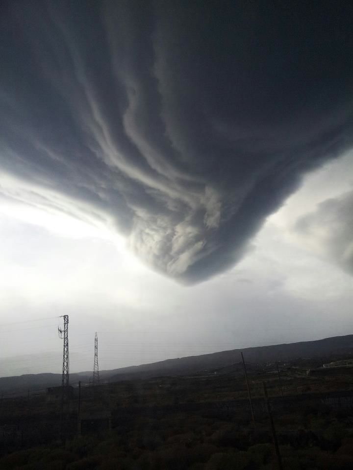 |
| This photo of a cloud formation was taken late this afternoon in the south of Tenerife with a mobile phone. The photo is real and not edited ! It was named 'nubepelicula' (movie cloud) and appeared in 'foro acanmet' (c) Rigoberto Rodríguez |
UPDATE #3 (10:55 pm):
The situation at the moment appears to have calmed, but forecasters are warning that the danger hasn't passed yet. There is a very charged atmosphere in the air with an unusually high temperature in some places.
Today saw lots of relatively minor incidents, such as cars damaged by fallen branches, some walls, fences, signs and lamp posts blown down. The worst affected areas were parts of the island of La Palma and the north of Tenerife. Flooding was minimal.
...and just when everyone started to expect more substantial rain, the unexpected happened:
A forest fire broke out in several places a couple of hours ago close to the town of Los Realejos on Tenerife.
The fire is in a pine forest close to a densely populated area and was caused by strong
winds blowing down a high-tension power line which supplies a large area. Now the power had to be switched off to allow fire brigades tackle the fire.
Rain would be welcome there now...
30-10-12 UPDATE #4 (11:55 pm):
 |
| Rain Radar 23:40 UTC |
A light rain is beginning to fall, but the rain radar is showing
ominous reflections moving in from the southwest...
The fire brigades are hoping to bring the fire in Los Realejos
under control within the next few hours
31-10-12 UPDATE #5 (1am):
 |
| Echotop Rain Radar 00:40 UTC |
The light rain has stopped again, but as of midnight tonight
there is an orange alert in effect for 30mm of rain in one
hour and up to 100mm in 12 hours.
As you can see on the latest radar screenshot the situation
is still developing...
31-10-12 UPDATE #6 ( 7am):
 |
| Echotop Rain Radar 06:40 UTC |
Persistent moderate rain has been falling for more than an hour now, especially on La Gomera and Tenerife. The rain appears to be intensifying. A short while ago I heard rocks falling in an uninhabited part of Valle Gran Rey.
Warnings are in effect until Thursday morning.
Warnings are in effect until Thursday morning.
31-10-12 UPDATE #7 (8:20am)
The rain has intensified and a thunderstorm is almost over Valle Gran Rey. The 'barranco' (a normally dry riverbed) is running with lots of water and debris.
People in the western Canary Islands have been asked not to travel unless necessary and to be very cautious if doing so.
The fire in Los Realejos, Tenerife has been brought under control with the help of the rain.
People in the western Canary Islands have been asked not to travel unless necessary and to be very cautious if doing so.
The fire in Los Realejos, Tenerife has been brought under control with the help of the rain.

31-10-12 UPDATE #8 (12 noon):
It has been raining continuously since early
this morning, but thankfully the rain was only moderate. A second thunderstorm over Valle Gran Rey about an hour ago passed without incident.
On La Gomera and on the other Canary islands only minor incidents and some traffic disruptions were reported up to now.
The satellite picture on the left shows the train of showers crossing the Canaries from
the southwest.
Roads are treacherous with flooding and debris: CAUTION !
31-10-12 UPDATE #9 ( 7pm) :
The continuous rain, which lasted for more than 8 hours stopped about half an hour after
my last post here, and we've only had a couple of light showers since then. The sun even came out for brief periods ! All in all a lot of rain came down, but thankfully no major incidents were reported in the Canary Islands. All preventive measures were applied and most people took precautions, thanks to the warnings and the preparedness of the authorities in the face of a potentially very dangerous situation.
The level of warnings has been lowered now to yellow and is in effect until tomorrow morning 9 am. The possibility of isolated heavy showers still exists on all of the Canary Islands, and strong wind gusts may still occur.
However, the worst is over for now.
Here's a photo I took at about sunset tonight, which shows a clearing sky in the west (on the right):

1 comment :
It's magnificent I didn't know about all this until I got to know this entry of yours over here. And I have a question for you. Do you have any valuable information on how to defend your personal intellectual property from being stolen?
Post a Comment