 |
| Wave height and direction forecast for Sat. morning 06 am UTC |
UPDATE SATURDAY, Nov. 29th 2014, @ 5 pm:
The storm is gradually abating, but warnings (see below) remain in place until midnight.
The Canary Islands will be slowly but surely getting back to normal tomorrow, Sunday Nov. 30th '14.
UPDATE SATURDAY, Nov. 29th 2014, @ 11 am:
La Gomera today is cut off from the 'rest of the world' as the airport remains closed and all ferries have been cancelled until 4 pm when sailings may be resumed, pending an improvement in weather conditions. There were many minor incidents such as blown down signage, solar panels, trees, etc., but thankfully no injuries have been reported. There are very high seas, especially on northern and western coasts and some minor damage to coastal infrastructure. Earlier this morning the strongest wind gust in the Canaries was recorded high in the mountains of Tenerife at Izaña where the wind reached 175 km/h.
The good news is that the worst is now over and the red alert has ended. The level orange warnings of strong wind and waves will remain in place until tonight, though.
Tomorrow the weather should gradually return to the normal pleasant conditions and the outlook for the early days of next week is for mostly fine weather.
UPDATE FRIDAY, Nov. 28th 2014, @ 4 pm:
Gale to storm force winds with hurricane force gusts continue in the Canary Islands where several inter-island and international flights are rescheduled, cancelled or diverted. Some minor roads closed. Ferry cancellations and rescheduling. Some minor accidents. Minor rockfalls and landslides.
UPDATE FRIDAY, Nov. 28th 2014, @ 1 pm:
The town of Agulo has been without electric power since early this morning. All schools and colleges on La Gomera have been closed. La Gomera airport is closed until further notice. Revised ferry timetables apply, but for how long ports can remain open is anybody's guess. CAUTION, the worst is yet to come !
UPDATE FRIDAY, Nov. 28th 2014, @ 11am:
The maximum wind gust warning value has already been exceeded on La Gomera this morning at the Igualero mountain station with about 100 mp/h (158 km/h):
Sea, air and land traffic is expected to be at times severely disrupted and there have been flight cancellations already. The 2.500-passenger TUI cruise ship 'Mein Schiff 3' will not visit La Gomera today as planned, and the Armas ferry to El Hierro island will not sail.
The storm is gradually abating, but warnings (see below) remain in place until midnight.
The Canary Islands will be slowly but surely getting back to normal tomorrow, Sunday Nov. 30th '14.
UPDATE SATURDAY, Nov. 29th 2014, @ 11 am:
La Gomera today is cut off from the 'rest of the world' as the airport remains closed and all ferries have been cancelled until 4 pm when sailings may be resumed, pending an improvement in weather conditions. There were many minor incidents such as blown down signage, solar panels, trees, etc., but thankfully no injuries have been reported. There are very high seas, especially on northern and western coasts and some minor damage to coastal infrastructure. Earlier this morning the strongest wind gust in the Canaries was recorded high in the mountains of Tenerife at Izaña where the wind reached 175 km/h.
The good news is that the worst is now over and the red alert has ended. The level orange warnings of strong wind and waves will remain in place until tonight, though.
Tomorrow the weather should gradually return to the normal pleasant conditions and the outlook for the early days of next week is for mostly fine weather.
UPDATE FRIDAY, Nov. 28th 2014, @ 4 pm:
Gale to storm force winds with hurricane force gusts continue in the Canary Islands where several inter-island and international flights are rescheduled, cancelled or diverted. Some minor roads closed. Ferry cancellations and rescheduling. Some minor accidents. Minor rockfalls and landslides.
UPDATE FRIDAY, Nov. 28th 2014, @ 1 pm:
The town of Agulo has been without electric power since early this morning. All schools and colleges on La Gomera have been closed. La Gomera airport is closed until further notice. Revised ferry timetables apply, but for how long ports can remain open is anybody's guess. CAUTION, the worst is yet to come !
UPDATE FRIDAY, Nov. 28th 2014, @ 11am:
The maximum wind gust warning value has already been exceeded on La Gomera this morning at the Igualero mountain station with about 100 mp/h (158 km/h):
| Racha (km/h) | |||||
|---|---|---|---|---|---|
| Estación | Provincia | Hora | km/h | Datos hasta | |
| Vallehermoso, Alto Igualero | Santa Cruz de Tenerife | 08:40 | 158 | 09:00 | |
| (La Gomera) | |||||
Sea, air and land traffic is expected to be at times severely disrupted and there have been flight cancellations already. The 2.500-passenger TUI cruise ship 'Mein Schiff 3' will not visit La Gomera today as planned, and the Armas ferry to El Hierro island will not sail.
Tree branches and other debris is causing delays on some roads. Even though the waves are still relatively benign the previously damaged coast road between Puntilla and La Playa in VGR has already suffered further damage. Peak wave heights of 5-6m are expected to occur between 2 and 6 am Nov 29th. and I doubt if this stretch of road will survive the night. CAUTION !
Avoid travel today and tomorrow, but if you're scheduled to do so check with your travel company before attempting any journey.
Avoid travel today and tomorrow, but if you're scheduled to do so check with your travel company before attempting any journey.
UPDATE FRIDAY, Nov. 28th 2014, @ 9am:
The Spanish Met. Office has elevated the warning level for wind to the highest (red) level: W-NW wind gust of 130 km/h are to be expected from now for the next 24 hours.All other warnings remain unchanged.
Now read the original post:
A vigorous depression north of the Canary Islands near the Iberian peninsula is expected to track SE and deepen. This will bring gale to storm force winds and high seas to the Canarian archipelago from early morning Friday 28th of November 2014 until at least early Sunday morning. Associated cold fronts will also bring showers or some longer spells of rain for a while and the temperature will decrease. Isolated thunderstorm activity may occur. However, the latter and the rainfalls pose a lesser threat than the wind and waves, and the fronts should pass through fairly rapidly. Conditions should have improved considerably by noon Monday.
Level orange warnings have been issued for westerly to north-westerly winds with gusts of up to 100 km/h. Even stronger gusts may be experienced in exposed areas and near mountains, where due to local turbulences 130 km/h wind gusts may occur.
Further, level orange warnings have been issued for Canarian waters and exposed coasts for waves of 5 to 6 metres in height. This is a wave height very rarely experienced in the Canary Islands and is potentially damaging to coastal defences and infrastructure. Rogue waves may be be even larger, and the combination of heavy swell, local tidal conditions and wind-blown waves is hard to predict.
BOTH ABOVE WARNINGS ARE VALID UNTIL LATE SATURDAY NIGHT, NOV. 29th, 2014
The Canarian Met. Assoc. have elevated their alert for wind and waves to the highest (red) level. Even Met Eireann forecasters here in Ireland have advised of this situation in several bulletins.
Please avoid mountain terrain and coastal areas and be extremely cautious generally.
The Canarian Met. Assoc. have elevated their alert for wind and waves to the highest (red) level. Even Met Eireann forecasters here in Ireland have advised of this situation in several bulletins.
Please avoid mountain terrain and coastal areas and be extremely cautious generally.
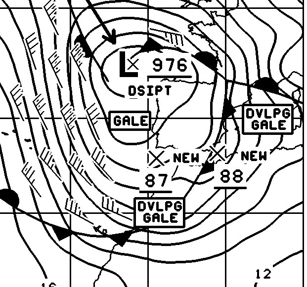 |
| OPC forecast chart for noon Friday, Nov.29th, 2014 |
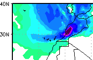 |
| Rain forecast for Friday noon. Note the heavy rain fcst. for Morocco, where dozens lost their lives in floods recently. |
No comments :
Post a Comment