After a relatively calm night with a much clearer sky, another band of showers is moving in from southwest. Weather warnings have been extended until this afternoon:
Showers (some heavy), isolated thunderstorms and strong and gusty winds on high ground are all imminent !
It is beginning to rain as I write in Valle Gran Rey, La Gomera.
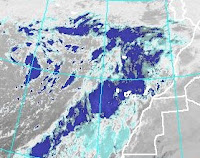
Satellite picture :

For history, details and development of this weather situation go to my previous post : Hurricane Sandy indirectly affecting Canary Islands
Updates:
#1 ( 5 pm):
The Spanish met. office (AEMET) has cancelled nearly all warnings in the Canaries (except for the island of La Palma and the mountain regions of Tenerife) up to and including Saturday.
The Canarian Society for Metereology (ACM), however has released a red alert warning of isolated thunderstorms, heavy showers, and strong and gusty winds in and near the mountains - with the western Canaries most at risk.I would take their advice and remain cautious.
The low to the west of the Canary Islands is still in place and slowly approaching, but It will eventually begin to gradually fill and weaken during its approach. It will still affect our weather negatively until Sunday at least, however.
The weather here on La Gomera today has been a mix of scattered moderate showers, moderate winds (stronger in the mountains) and some sunny spells. The temperature remains fairly high for this type of weather at around 25ºC.
There are no reports of any significant incidents, but roads and paths remain dangerous with lots of debris being reported. Lots of crews are out on this public holiday clearing roads and blocked drains.
 |
| Enhanced Satellite image of late this afternoon. (NOAA) |
#2 ( 8 pm):

It has been raining moderately for the past 45 minutes and
as you can see on the rainfall radar, the band of showers
has reached the Canary Islands and La Gomera cannot be
seen under the rain reflection on the screen, As I write the rain is increasing ...
...and 10 minutes later decreases to light...
...and 10 minutes later decreases to light...
#3 ( 10:15 pm):

Heavy rain has been falling in Valle Gran Rey
for the past 30 minutes and visibility is
greatly reduced.
All observations show that cells of heavy precipitacion
have developed very rapidly to the SW and have reached
the SW of the Canary Islands.
#4 ( 01/11/12 - 11:45 pm ):

There's no let-up ! Still raining quite strongly, and the
barranco (a normally dry riverbed on the floor of the
valley) is like a river in spate now.
The heavy rain has reached many parts of Tenerife now, not to mention the island of El Hierro.
... ah yes, the spanish official weather service under the Madrid ministry for the environment (etc.) has woken up to the facts on this holiday and has issued a rain warning again.
#5 (02/11/12 - 1:30 am)

It is still raining in Valle Gran
Rey and many parts of the western Canaries.
In Valle Gran Rey we're possibly
a bit more worried because 71 years ago on Halloween 1941 there was an event locally referred to as 'the great flood',when torrential rain did a lot of damage here and in other parts of the island. Lives and livestock were lost and to this day the event is regularly remembered and discussed.
During yesterday some places in the western islands registered between 50 and 100 litres/m2 of rain already.
On the right the 'rainbow' satellite picture taken at midnight (Meteosat/NOAA)
#6 (02/11/12 - 3:30 am):

Still raining and now there's a thunderstorm not too far
away in the southwest with a very low rumbling thunder.
This radar screenshot on the right shows the accumulated precipitation for the past six hours. El Hierro as well as parts of Tenerife got most of it, with La Gomera showing the highest amount.
#7...at 7 am (02/11/12)
...still raining, but there was very little wind all night where I live. There were a good few rockfalls during the past few hours and the thunderstorm lasted for more than an hour, but discharged mostly over the sea. The rain was mainly moderate, but quite heavy at times.
A big bulldozer went up the mountain on themain road in the dead of night - probably to clear the road of rocks and debris.
The three images are basically the same satellite picture
 taken at 6 am from Eumetsat but have undergone different
enhancements by NOAA to allow a more precise interpretation.
On the top right is 'infrared 2', below that is 'avn' (used for aviation), and at the bottom right water vapour is shown more clearly.
Anyway all three testify that there is still plenty of development taking place when compared with previous images.


All images can be clicked to enlarge
... ah yes, the spanish official weather service under the Madrid ministry for the environment (etc.) has woken up to the facts on this holiday and has issued a rain warning again.
#5 (02/11/12 - 1:30 am)

It is still raining in Valle Gran
Rey and many parts of the western Canaries.
In Valle Gran Rey we're possibly
a bit more worried because 71 years ago on Halloween 1941 there was an event locally referred to as 'the great flood',when torrential rain did a lot of damage here and in other parts of the island. Lives and livestock were lost and to this day the event is regularly remembered and discussed.
During yesterday some places in the western islands registered between 50 and 100 litres/m2 of rain already.
On the right the 'rainbow' satellite picture taken at midnight (Meteosat/NOAA)
#6 (02/11/12 - 3:30 am):

Still raining and now there's a thunderstorm not too far
away in the southwest with a very low rumbling thunder.
This radar screenshot on the right shows the accumulated precipitation for the past six hours. El Hierro as well as parts of Tenerife got most of it, with La Gomera showing the highest amount.
#7...at 7 am (02/11/12)
...still raining, but there was very little wind all night where I live. There were a good few rockfalls during the past few hours and the thunderstorm lasted for more than an hour, but discharged mostly over the sea. The rain was mainly moderate, but quite heavy at times.
A big bulldozer went up the mountain on themain road in the dead of night - probably to clear the road of rocks and debris.
The three images are basically the same satellite picture

enhancements by NOAA to allow a more precise interpretation.
On the top right is 'infrared 2', below that is 'avn' (used for aviation), and at the bottom right water vapour is shown more clearly.
Anyway all three testify that there is still plenty of development taking place when compared with previous images.


All images can be clicked to enlarge
The rain just now has become very
light, and later today the weather should
improve considerably - but CAUTION: there remains a risk of sudden changes.
#8 at 8:30 am (02/11/12):
 |
| The 'barranco' during the pause in the rain early this morning |
 |
More bands of precipitation moving in from SW (8:20 am) |
#9 at 10:30 am (02/11/12):
The rain has stopped for the time being here in Valle Gran Rey on La Gomera and the sky is still overcast but much brighter.
Rain is however being reported from other areas in the Canaries and more rain in the form of showers is forecast for the next couple of days, but more breaks are likely. With the almost tropical air coming up from the SW the temperature should remain pleasantly high. ACM have just lowered their alert level from red to orange, while AEMET have issued yellow warnings for wind and rain from today and until Sunday.
Ports and airports are operating normally and no significant incidents were reported.
Locals are welcoming the rain like an early Christmas present !

#10 at 1:25 pm (02/11/12):
It is starting again - a thunderstorm is fairly close to La Gomera,getting closer every minute, and rain of large drops is falling.
 |
| Radar image taken at 1:10 pm |
#11 at 5:45 pm (02/11/12):
Well, well, well - since the last update I was 'out and about' a lot and had to witness a
cloudburst, of such intensity and duration - so locals tell me - that hasn't happened since 1975.
I'm soaked to the bone, just arrived home tired, hungry and wet, with gigabytes of poor quality visual footage to sort out, information from the 'elders' to mull over, after discussing historical weather events with local farmers and fishermen while humouring disgruntled and stuck tourists. In short: I could write an illustrated book about the past few hours...
So please bear with me and maybe you won't be disappointed. It just might take some (?) more time, if I don't just collapse with fatigue.
Hope to see you later...
Go to homepage or click: Weather warnings still in effect in Canary Islands
No comments :
Post a Comment